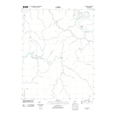
2011 Map of Winslow
USGS Topo · Published 2011About this map
The Guyandotte River flows through the northeast corner of this Cabell County landscape, where the small community of Owens Crossing serves as a local landmark. The terrain is defined by a dense network of creek valleys and ridges, with Beech Fork and Heath Creek carving deep paths through the hills. Small settlements like Winslow, Bowen, and Sarah are connected by winding corridor roads such as Stringtown Rd and Old Co 13. For those researching local heritage, the map identifies several family and community burial sites, including Crooks Cemetery, Wallace Cemetery, Bowen Cemetery, and Baylous Cemetery. On the higher elevations, the Cabell Lookout Tower stands near the southern boundary, while Camp Dekanawida is situated along the riverbanks to the north, illustrating the mix of residential life, timber-era infrastructure, and recreational spaces in this part of West Virginia.
Find a feature on this map
62 named features on this map. Tap any name to fly to it.
Don’t see what you’re looking for? This feature index may not catch every label — zoom into the map to look around manually.
Map Details
Editions of this 2011 Winslow Map
This is the sole edition of this map. No revisions or reprints were ever made.
Other maps of this area

1892 · Huntington
USGS Topo · 1:125,000

1898 · Huntington
USGS Topo · 1:125,000

1901 · Guyandot
USGS Topo · 1:62,500

1902 · Guyandot
USGS Topo · 1:62,500

1902 · Milton
USGS Topo · 1:62,500

1902 · Midkiff
USGS Topo · 1:62,500

1907 · Midkiff
USGS Topo · 1:62,500

1909 · Wayne
USGS Topo · 1:62,500

1909 · Midkiff
USGS Topo · 1:62,500

1931 · Wayne
USGS Topo · 1:62,500