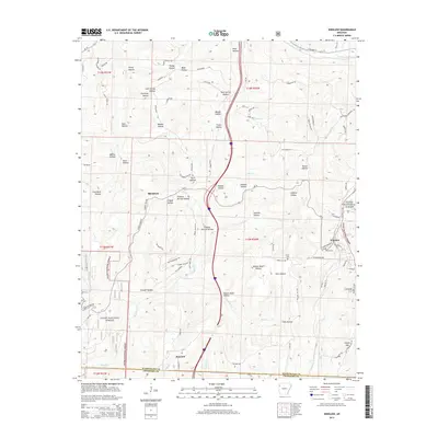
2014 Map of Winslow
USGS Topo · Published 2014About this map
Winslow and the high ridges of the Ozark National Forest dominate this landscape at the Washington and Crawford County line. The settlement pattern follows the intricate drainage networks of the W Fork White River, Blackburn Creek, and Winn Creek, where steep hollows are often named for the families who settled them. Local history is anchored by the Collier Cem and Kelton Cem, as well as small communities like Blackburn and Banyard. The terrain is characterized by a series of deep ravines, including Filmore Parrish Hollow, Rotten Bluff Hollow, and Gafield Hollow. Significant infrastructure such as S Highway 71 and various forest roads wind through the topography, connecting the elevated reaches of Gaylor Mtn to the valley floors, illustrating how modern transportation has adapted to the challenging Ozark relief.
Find a feature on this map
92 named features on this map. Tap any name to fly to it.
Don’t see what you’re looking for? This feature index may not catch every label — zoom into the map to look around manually.
Map Details
Editions of this 2014 Winslow Map
This is the sole edition of this map. No revisions or reprints were ever made.
Other maps of this area

1898 · Winslow #4
USGS Topo · 1:62,500

1898 · Winslow #3
USGS Topo · 1:62,500

1898 · Winslow
USGS Topo · 1:125,000

1901 · Winslow
USGS Topo · 1:125,000

1946 · Fort Smith
USGS Topo · 1:250,000

1965 · Fort Smith
USGS Topo · 1:250,000

1967 · Fort Smith
USGS Topo · 1:250,000
1969 · Fern
USGS Topo · 1:24,000
1969 · Mountainburg
USGS Topo · 1:24,000
1970 · Rudy NE
USGS Topo · 1:24,000