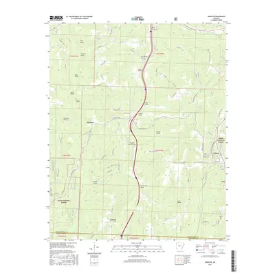
2017 Map of Winslow
USGS Topo · Published 2017About this map
Winslow sits at a high point in the Ozarks, surrounded by a complex network of drainages that feed the W Fork White River and Lee Cr. This 2017 study illustrates the deeply incised landscape where naming conventions reflect the utilitarian history of the land, including Coal Bank Hollow, Rich Hollow, and Honey Hollow. The rugged terrain of the Ozark National Forest dominates the southern and western portions of the quadrangle, crossed by the Butterfield Hiking Trail and numerous secondary routes like Old Cabin Rd. Small settlements such as Blackburn and Banyard are positioned along the winding valley floors, while historic family burial sites like Kelton Cem and Collier Cem provide anchor points for genealogists. The map also traces the drainage divide where Blackburn Cr flows south toward the Arkansas River while northern streams join the White River system.
Find a feature on this map
85 named features on this map. Tap any name to fly to it.
Don’t see what you’re looking for? This feature index may not catch every label — zoom into the map to look around manually.
Map Details
Editions of this 2017 Winslow Map
This is the sole edition of this map. No revisions or reprints were ever made.
Other maps of this area

1898 · Winslow #4
USGS Topo · 1:62,500

1898 · Winslow #3
USGS Topo · 1:62,500

1898 · Winslow
USGS Topo · 1:125,000

1901 · Winslow
USGS Topo · 1:125,000

1946 · Fort Smith
USGS Topo · 1:250,000

1965 · Fort Smith
USGS Topo · 1:250,000

1967 · Fort Smith
USGS Topo · 1:250,000
1969 · Fern
USGS Topo · 1:24,000
1969 · Mountainburg
USGS Topo · 1:24,000
1970 · Rudy NE
USGS Topo · 1:24,000