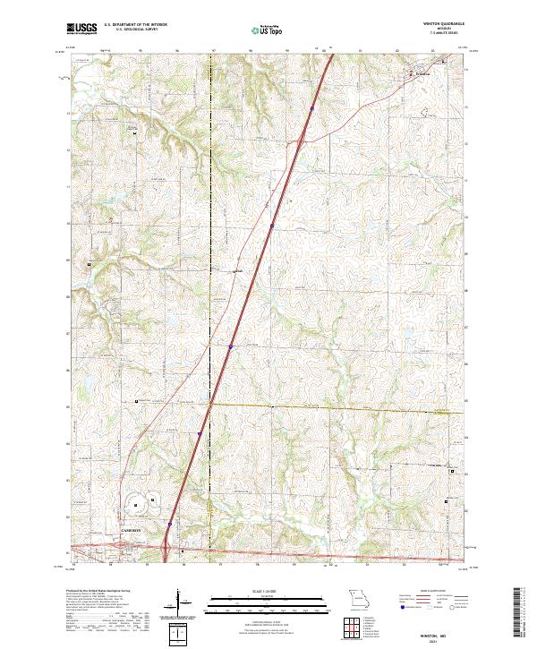
2021 Map of Winston
USGS Topo · Published 2021About this map
The town of Winston and the crossroads of Mabel anchor this North Central Missouri landscape, situated where the borders of Daviess, DeKalb, and Caldwell counties converge. The terrain is defined by a dense network of drainage, including the headwaters of Marrowbone Cr and Long Br, which wind through agricultural fields and wooded creek beds. For genealogists and local historians, the sheet is particularly valuable for its density of rural burial grounds, including the Wamsley Cem, Delano Cem, and Christian Chapel Cem. To the southwest, the northern edge of Cameron is visible, showing the early 21st-century residential and street expansion near E Baldwin St and McElwain Dr. The land is dotted with several small water bodies like DeKalb A-33 Lake and A-26 Lake, reflecting the region's managed water resources for livestock and recreation.
Find a feature on this map
58 named features on this map. Tap any name to fly to it.
Don’t see what you’re looking for? This feature index may not catch every label — zoom into the map to look around manually.
Map Details
Editions of this 2021 Winston Map
This is the sole edition of this map. No revisions or reprints were ever made.
Other maps of this area

1923 · Maysville
USGS Topo · 1:62,500

1924 · Polo
USGS Topo · 1:62,500

1924 · Winston
USGS Topo · 1:62,500

1925 · Plattsburg
USGS Topo · 1:62,500

1925 · Maysville
USGS Topo · 1:62,500

1950 · Kansas City
USGS Topo · 1:250,000

1954 · Kansas City
USGS Topo · 1:250,000

1956 · Kansas City
USGS Topo · 1:250,000

1960 · Kansas City
USGS Topo · 1:250,000
1983 · Maysville
USGS Topo · 1:24,000