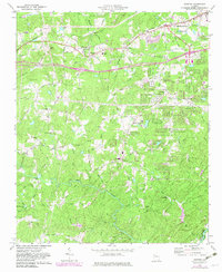
1973 Map of Winston
USGS Topo · Published 1983About this map
Bill Arp and Winston serve as focal points for this Douglas County landscape, where the rural character is increasingly marked by suburban expansion and transportation corridors. The Southern Railway and several major roads like Conners Road and Dorsett Shoals Road cut across the northern terrain, connecting local communities to the larger hub of Douglasville. The map captures a high density of rural institutions, particularly churches such as Faith Deliverance Ch, Antioch Ch, and Shady Grove Ch, which often served as the social anchors for these unincorporated areas.
Find a feature on this map
50 named features on this map. Tap any name to fly to it.
Don’t see what you’re looking for? This feature index may not catch every label — zoom into the map to look around manually.
Map Details
Editions of this 1973 Winston Map
3 editions found
Other maps of this area

1891 · Marietta
USGS Topo · 1:125,000

1895 · Marietta
USGS Topo · 1:125,000

1897 · Marietta
USGS Topo · 1:125,000

1901 · Marietta
USGS Topo · 1:125,000

1953 · Atlanta
USGS Topo · 1:250,000

1954 · Palmetto
USGS Topo · 1:24,000

1954 · Campbellton
USGS Topo · 1:24,000

1954 · Austell
USGS Topo · 1:24,000

1957 · Atlanta
USGS Topo · 1:250,000

1958 · Rico
USGS Topo · 1:24,000