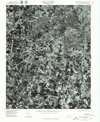
1977 Map of Winston-Salem West
USGS Topo · Published 1979About this map
The western expansion of Winston-Salem is captured during the late 1970s in this orthophotograph produced by the Department of the Interior. The map reveals the intricate texture of established residential neighborhoods like Ardmore and Buena Vista, contrasting with the more rural, wooded fringes near Clemmons. The winding course of Muddy Creek carves through the landscape, providing a natural baseline against the geometric progression of suburban development and the massive interstate interchanges that define the modern era. Industrial and commercial hubs such as Hanes are visible alongside local districts like Reynolda and Rosemont. By utilizing aerial imagery rather than traditional line work, this survey provides researchers a literal view of the land use, from the cleared fields near Mt Tabor to the dense street grids of Five Points.
Find a feature on this map
10 named features on this map. Tap any name to fly to it.
Don’t see what you’re looking for? This feature index may not catch every label — zoom into the map to look around manually.
Map Details
Editions of this 1977 Winston-Salem West Map
This is the sole edition of this map. No revisions or reprints were ever made.
Other maps of this area

1949 · Eller
USGS Topo · 1:24,000

1950 · Winston-Salem West
USGS Topo · 1:24,000

1950 · Winston-Salem East
USGS Topo · 1:24,000

1951 · Winston-Salem West
USGS Topo · 1:24,000

1951 · Winston-Salem East
USGS Topo · 1:24,000

1951 · Rural Hall
USGS Topo · 1:24,000

1951 · Walkertown
USGS Topo · 1:24,000

1953 · Charlotte
USGS Topo · 1:250,000

1953 · Winston-Salem
USGS Topo · 1:250,000

1954 · Charlotte
USGS Topo · 1:250,000
Featured Places
- Winston-Salem, NC
- Clemmons, NC
- South Fork, Winston-Salem
- Echo Bluff Trailer Park, NC
- West Highlands, Winston-Salem