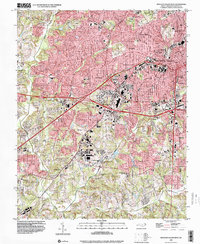
1997 Map of Winston-Salem West
USGS Topo · Published 2001About this map
Mt Tabor rises as a prominent landmark in this 1997 update of the western Forsyth County landscape, where the suburban expansion of Winston-Salem meets older rural foundations. The map reveals a dense network of neighborhoods like Buena Vista, Ardmore, and West Highlands, centered around vital institutions such as Baptist Hospital and Reynolda Park. This era of mapping shows the significant infrastructure of the Silas Creek Parkway and various interchanges, illustrating how mid-century residential growth was being knit together by a modernizing highway system.
Find a feature on this map
47 named features on this map. Tap any name to fly to it.
Don’t see what you’re looking for? This feature index may not catch every label — zoom into the map to look around manually.
Map Details
Editions of this 1997 Winston-Salem West Map
This is the sole edition of this map. No revisions or reprints were ever made.
Other maps of this area

1949 · Eller
USGS Topo · 1:24,000

1950 · Winston-Salem West
USGS Topo · 1:24,000

1950 · Winston-Salem East
USGS Topo · 1:24,000

1951 · Winston-Salem West
USGS Topo · 1:24,000

1951 · Winston-Salem East
USGS Topo · 1:24,000

1951 · Rural Hall
USGS Topo · 1:24,000

1951 · Walkertown
USGS Topo · 1:24,000

1953 · Charlotte
USGS Topo · 1:250,000

1953 · Winston-Salem
USGS Topo · 1:250,000

1954 · Charlotte
USGS Topo · 1:250,000
Featured Places
- Winston-Salem, NC
- Clemmons, NC
- South Fork, Winston-Salem
- Echo Bluff Trailer Park, NC
- West Highlands, Winston-Salem