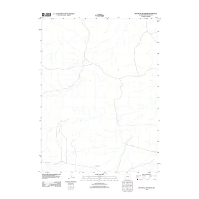
2012 Map of Winter Fat Reservoir
USGS Topo · Published 2012About this map
Winter Fat Reservoir lies in the southern reaches of this High Plains landscape, serving as a rare hydrological anchor in an otherwise arid expanse of Sweetwater County. The terrain is defined by a complex network of intermittent drainage channels that carve through the high desert, illustrating the ephemeral nature of water in this part of Wyoming. This 2012 survey by the U.S. Geological Survey details the isolated road network and topography of the region, providing a baseline for environmental and land use studies in a portion of the state where human infrastructure remains minimal.
Find a feature on this map
1 named feature on this map. Tap any name to fly to it.
Don’t see what you’re looking for? This feature index may not catch every label — zoom into the map to look around manually.
Map Details
Editions of this 2012 Winter Fat Reservoir Map
This is the sole edition of this map. No revisions or reprints were ever made.
Other maps of this area

1954 · Rock Springs
USGS Topo · 1:250,000

1957 · Mc Kinnon Junction
USGS Topo · 1:62,500

1958 · Rock Springs
USGS Topo · 1:250,000

1962 · Rock Springs
USGS Topo · 1:250,000

1964 · Antelope Knoll NE
USGS Topo · 1:24,000

1964 · Black Spring Reservoir
USGS Topo · 1:24,000

1964 · Antelope Knoll
USGS Topo · 1:24,000

1964 · Winter Fat Reservoir
USGS Topo · 1:24,000
1964 · Horse Ranch
USGS Topo · 1:24,000
1964 · Needle Reservoir
USGS Topo · 1:24,000