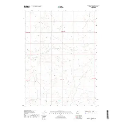
2017 Map of Winter Fat Reservoir
USGS Topo · Published 2017About this map
Winter Fat Reservoir serves as a primary reference point in this arid high-elevation landscape within Sweetwater County. The terrain is defined by complex drainage systems and township divisions, including the convergence of t16n r110w and t15n r110w. The intermittent flow of Big Dry Cr meanders across the northern sections, illustrating the seasonal water patterns characteristic of the Wyoming basin. This 2017 survey reflects the contemporary land management of the region, emphasizing hydrological features and public land boundaries established by the U.S. Geological Survey and the Bureau of Land Management. The map provides a detailed view of the section lines and township ranges, such as t15n r111w and t15n r109w, which are essential for property research and understanding the large-scale ranching and mineral lease layouts of southern Wyoming.
Find a feature on this map
7 named features on this map. Tap any name to fly to it.
Don’t see what you’re looking for? This feature index may not catch every label — zoom into the map to look around manually.
Map Details
Editions of this 2017 Winter Fat Reservoir Map
This is the sole edition of this map. No revisions or reprints were ever made.
Other maps of this area

1954 · Rock Springs
USGS Topo · 1:250,000

1957 · Mc Kinnon Junction
USGS Topo · 1:62,500

1958 · Rock Springs
USGS Topo · 1:250,000

1962 · Rock Springs
USGS Topo · 1:250,000

1964 · Antelope Knoll NE
USGS Topo · 1:24,000

1964 · Black Spring Reservoir
USGS Topo · 1:24,000

1964 · Antelope Knoll
USGS Topo · 1:24,000

1964 · Winter Fat Reservoir
USGS Topo · 1:24,000
1964 · Horse Ranch
USGS Topo · 1:24,000
1964 · Needle Reservoir
USGS Topo · 1:24,000