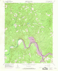
1963 Map of Winterpock
USGS Topo · Published 1969About this map
The Appomattox River winds through this landscape, forming the boundary between Chesterfield and Amelia counties and widening significantly into Lake Appomattox Chesdin. This waterway dominates the southern half of the area, creating features like Goose Island and receiving drainage from several winding streams, including Winticomack Creek and Pillarleg Branch. The 1968 photorevisions highlight the rising waters of the reservoir, a major change to the riverine environment.
Find a feature on this map
21 named features on this map. Tap any name to fly to it.
Don’t see what you’re looking for? This feature index may not catch every label — zoom into the map to look around manually.
Map Details
Editions of this 1963 Winterpock Map
4 editions found
Other maps of this area

1897 · Amelia
USGS Topo · 1:125,000

1943 · Chesterfield
USGS Topo · 1:31,680

1943 · Goodes Bridge
USGS Topo · 1:31,680

1943 · Hallsboro
USGS Topo · 1:31,680

1943 · Beach
USGS Topo · 1:24,000

1943 · Clayville
USGS Topo · 1:24,000

1943 · Church Road
USGS Topo · 1:24,000

1943 · Winterpock
USGS Topo · 1:24,000

1943 · Sutherland
USGS Topo · 1:24,000

1943 · Richmond
USGS Topo · 1:250,000