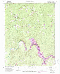
1963 Map of Winterpock
USGS Topo · Published 1987About this map
Winterpock and the surrounding woodlands of Chesterfield County are captured here during a period of transition as the Appomattox River was transformed by the creation of Lake Chesdin. This survey shows the expanded reservoir reaching into the rural landscape, partially submerging the river valley near Goose Island. The area maintains its established community character, centered around local institutions like the Winterpock Sch and a network of country churches including Centenary Ch, Tabernacle Ch, and Bethia Ch.
Find a feature on this map
21 named features on this map. Tap any name to fly to it.
Don’t see what you’re looking for? This feature index may not catch every label — zoom into the map to look around manually.
Map Details
Editions of this 1963 Winterpock Map
4 editions found
Other maps of this area

1897 · Amelia
USGS Topo · 1:125,000

1943 · Chesterfield
USGS Topo · 1:31,680

1943 · Goodes Bridge
USGS Topo · 1:31,680

1943 · Hallsboro
USGS Topo · 1:31,680

1943 · Beach
USGS Topo · 1:24,000

1943 · Clayville
USGS Topo · 1:24,000

1943 · Church Road
USGS Topo · 1:24,000

1943 · Winterpock
USGS Topo · 1:24,000

1943 · Sutherland
USGS Topo · 1:24,000

1943 · Richmond
USGS Topo · 1:250,000