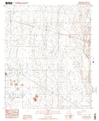
1984 Map of Wintersburg
USGS Topo · Published 1984About this map
The Palo Verde Nuclear Generating Station dominates the southwestern corner of this desert landscape, its industrial infrastructure appearing alongside a developing network of section roads and irrigation channels. This mid-1980s survey captures the intersection of traditional agricultural routes and high-tech energy production in the Sonoran desert west of Phoenix. The settlement of Wintersburg sits at the junction of Salome Highway and Wintersburg Road, serving as a focal point for local life alongside the Ruth Fisher Sch. To the east, the wide, sandy bed of the Hassayampa River forms a natural eastern boundary, while a series of desert drainages including Fourmile Wash, Phillips Wash, and Luke Wash score the terrain from north to south. Notable markers of local infrastructure like a Landing Strip and a Radio Tower illustrate the era's reliance on air and radio communication in this expansive environment.
Find a feature on this map
20 named features on this map. Tap any name to fly to it.
Don’t see what you’re looking for? This feature index may not catch every label — zoom into the map to look around manually.
Map Details
Editions of this 1984 Wintersburg Map
2 editions found
Other maps of this area

1954 · Phoenix
USGS Topo · 1:250,000

1957 · Phoenix
USGS Topo · 1:250,000

1957 · White Tank Mts.
USGS Topo · 1:62,500

1958 · Phoenix
USGS Topo · 1:250,000

1958 · Buckeye NW
USGS Topo · 1:24,000

1958 · Hassayampa
USGS Topo · 1:24,000

1958 · Buckeye
USGS Topo · 1:62,500

1960 · Phoenix
USGS Topo · 1:250,000

1962 · Belmont Mts
USGS Topo · 1:62,500

1962 · Arlington
USGS Topo · 1:62,500