
1951 Map of Winthrop
USGS Topo · Published 1951About this map
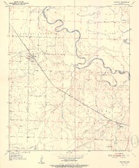
The Kansas City Southern railroad dictates the settlement pattern of this southwest Arkansas landscape, cutting a diagonal path across the Little River and Sevier County boundary. The town of Winthrop serves as a primary hub along the line, positioned just south of the winding Little River and the mouth of Hurricane Creek. To the east, the terrain becomes increasingly complex with oxbows and marshy features like Red Lake and Boggy Slough, indicating a low-lying riparian environment subject to the river's historical shifts.
Find a feature on this map
17 named features on this map. Tap any name to fly to it.
Don’t see what you’re looking for? This feature index may not catch every label — zoom into the map to look around manually.
Map Details
Editions of this 1951 Winthrop Map
2 editions found
Other maps of this area

1950 · Ashdown West
USGS Topo · 1:24,000

1950 · Falls Chapel
USGS Topo · 1:24,000

1950 · Winthrop
USGS Topo · 1:24,000

1951 · Ashdown West
USGS Topo · 1:24,000

1951 · Falls Chapel
USGS Topo · 1:24,000

1951 · Arden
USGS Topo · 1:24,000

1951 · Arkinda
USGS Topo · 1:24,000

1951 · Cerrogordo
USGS Topo · 1:24,000

1951 · Horatio
USGS Topo · 1:24,000

1951 · Lockesburg
USGS Topo · 1:24,000