
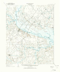
1908 Map of Winton
USGS Topo · Published 1944About this map
The confluence of the Meherrin River and the Chowan River defines the landscape of northeastern North Carolina in this early twentieth-century survey. The town of Winton serves as a central hub along the riverbanks, while Tunis and South Tunis mark critical points where the Atlantic Coast Line crosses the water. The area's agricultural and timber-based economy is evident in the numerous named swamps and pocosons, such as Whiteoak Pocoson and Ahoskie Swamp, which are interspersed with local landmarks like Dildys Mill and Cessons Mill.
Find a feature on this map
108 named features on this map. Tap any name to fly to it.
Don’t see what you’re looking for? This feature index may not catch every label — zoom into the map to look around manually.
Map Details
Editions of this 1908 Winton Map
2 editions found
Other maps of this area

1904 · Edenton
USGS Topo · 1:62,500

1906 · Beckford
USGS Topo · 1:48,000

1907 · Beckford
USGS Topo · 1:62,500

1919 · Suffolk
USGS Topo · 1:62,500

1919 · Boykins
USGS Topo · 1:48,000

1920 · Holland
USGS Topo · 1:62,500

1920 · Boykins
USGS Topo · 1:62,500

1940 · Beckford
USGS Topo · 1:62,500

1942 · Edenton
USGS Topo · 1:62,500

1943 · Holland
USGS Topo · 1:62,500