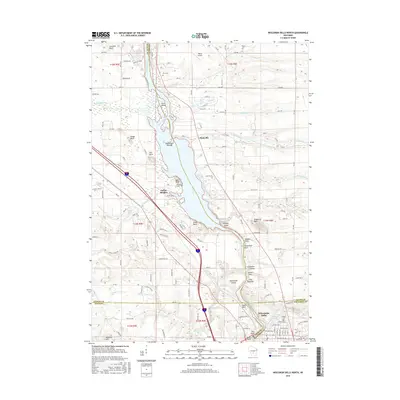
2016 Map of Wisconsin Dells North
USGS Topo · Published 2016About this map
The Wisconsin River carves a dramatic path through this 2016 survey, defining the intersection of Juneau, Adams, Sauk, and Columbia counties. The map details the transition between the Upper Dells and Lower Dells, highlighting the intricate sandstone formations that have long made this region a destination. Named landmarks such as Stand Rock, Witches Gulch, and Steamboat Rock are documented along the river's edge, while Blackhawk Island sits just north of the Wisconsin Dells town center. Away from the water, the landscape includes the settlement of Plainville and several small family and community burial grounds, including Olin Cem and Dupless Cem. This record of the modern shoreline and local infrastructure preserves the names of the small ravines and glens, like Artist Glen and Coldwater Canyon, that comprise the region's unique geography.
Find a feature on this map
137 named features on this map. Tap any name to fly to it.
Don’t see what you’re looking for? This feature index may not catch every label — zoom into the map to look around manually.
Map Details
Editions of this 2016 Wisconsin Dells North Map
This is the sole edition of this map. No revisions or reprints were ever made.
Other maps of this area

1901 · The Dells
USGS Topo · 1:62,500

1902 · Briggsville
USGS Topo · 1:62,500

1957 · Wisconsin Dells
USGS Topo · 1:62,500

1957 · Madison
USGS Topo · 1:250,000

1958 · Briggsville
USGS Topo · 1:62,500

1960 · Madison
USGS Topo · 1:250,000

1961 · Oxford
USGS Topo · 1:62,500

1961 · Adams
USGS Topo · 1:62,500
1975 · Wisconsin Dells NW
USGS Topo · 1:24,000
1975 · Wisconsin Dells SE
USGS Topo · 1:24,000