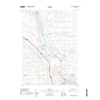
2018 Map of Wisconsin Dells North
USGS Topo · Published 2018About this map
The Wisconsin River carves a deep path through the driftless-style geology of south-central Wisconsin, defining the borders of Juneau, Adams, Sauk, and Columbia counties. The river corridor is marked by distinctive sandstone formations and narrow passages like The Narrows, Witches Gulch, and Coldwater Canyon. In the southern portion of the map, the city of Wisconsin Dells serves as a hub near the Upper Dells, while Indian Heights and Plainville occupy the higher ground to the north.
Find a feature on this map
99 named features on this map. Tap any name to fly to it.
Don’t see what you’re looking for? This feature index may not catch every label — zoom into the map to look around manually.
Map Details
Editions of this 2018 Wisconsin Dells North Map
This is the sole edition of this map. No revisions or reprints were ever made.
Other maps of this area

1901 · The Dells
USGS Topo · 1:62,500

1902 · Briggsville
USGS Topo · 1:62,500

1957 · Wisconsin Dells
USGS Topo · 1:62,500

1957 · Madison
USGS Topo · 1:250,000

1958 · Briggsville
USGS Topo · 1:62,500

1960 · Madison
USGS Topo · 1:250,000

1961 · Oxford
USGS Topo · 1:62,500

1961 · Adams
USGS Topo · 1:62,500
1975 · Wisconsin Dells NW
USGS Topo · 1:24,000
1975 · Wisconsin Dells SE
USGS Topo · 1:24,000