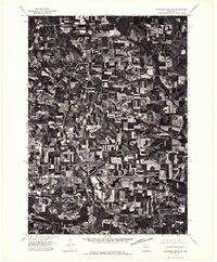
1975 Map of Wisconsin Dells SW
USGS Topo · Published 1976About this map
Agricultural patterns and wooded coulees dominate the landscape of Sauk County in the mid-1970s. This orthophotoquad reveals the intricate textures of contour plowing and farmstead layouts surrounding the eastern outskirts of Reedsburg. Unlike traditional topographic maps, this aerial perspective from the U.S. Geological Survey provides a literal view of the land use, showing the dense concentration of farm buildings and the winding network of rural roads that connect these upland properties. The sharp contrast between the dark, forested slopes and the pale, multi-toned geometric crop fields highlights the area's transition from the developed town center to the surrounding dairy country.
Find a feature on this map
1 named feature on this map. Tap any name to fly to it.
Don’t see what you’re looking for? This feature index may not catch every label — zoom into the map to look around manually.
Map Details
Editions of this 1975 Wisconsin Dells SW Map
2 editions found
Other maps of this area

1901 · Denzer
USGS Topo · 1:62,500

1901 · The Dells
USGS Topo · 1:62,500

1905 · Richland Center
USGS Topo · 1:125,000

1956 · Reedsburg
USGS Topo · 1:62,500

1957 · Wisconsin Dells
USGS Topo · 1:62,500

1957 · Madison
USGS Topo · 1:250,000

1958 · North Freedom
USGS Topo · 1:62,500

1958 · La Crosse
USGS Topo · 1:250,000

1960 · Madison
USGS Topo · 1:250,000

1960 · Plain
USGS Topo · 1:62,500