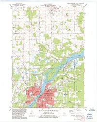
1984 Map of Wisconsin Rapids North
USGS Topo · Published 1984About this map
Wisconsin Rapids and the industrial village of Biron anchor the southern half of this mid-1980s landscape, where the Wisconsin River transitions from the wide Biron Flowage into a complex channel filled with large islands like Hunter Island and Belle Island. The map illustrates a distinctive regional economy, showing the extensive Cranberry Bogs east of the river and several large industrial waste sites and paper-related infrastructure. In the town of Rudolph to the north, the presence of Holy Rosary Ch and St Philomena Cem provides a focal point for genealogical research. The transportation network is defined by the Soo Line and Chicago and North Western railroads, which served the heavy industry and mills that characterized the Wood County river valley during this era. Public institutions including Assumption High Sch and the Mid State Technical Institute highlight the area's development as a regional hub.
Find a feature on this map
80 named features on this map. Tap any name to fly to it.
Don’t see what you’re looking for? This feature index may not catch every label — zoom into the map to look around manually.
Map Details
Editions of this 1984 Wisconsin Rapids North Map
This is the sole edition of this map. No revisions or reprints were ever made.
Other maps of this area

1955 · Green Bay
USGS Topo · 1:250,000

1956 · Milladore
USGS Topo · 1:48,000

1956 · Stevens Point
USGS Topo · 1:48,000

1957 · Wisconsin Rapids
USGS Topo · 1:48,000

1957 · Whiting
USGS Topo · 1:48,000

1967 · Wisconsin Rapids
USGS Topo · 1:62,500

1970 · Kellner
USGS Topo · 1:24,000

1970 · Junction City
USGS Topo · 1:24,000
1970 · Sherry
USGS Topo · 1:24,000
1970 · Rocky Run
USGS Topo · 1:24,000