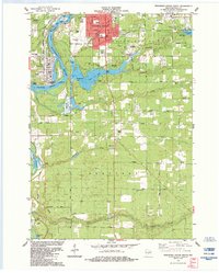
1984 Map of Wisconsin Rapids South
USGS Topo · Published 1984About this map
Industrial and residential development along the Wisconsin River defines this 1980s landscape south of Wisconsin Rapids. The southern expansion of Port Edwards is clear, with its corporate boundaries extending toward the Chicago and North Western rail lines and the Industrial Waste Ponds that speak to the region's paper-milling heritage. Between the river and Nepco Lake, a series of numbered streams—Onemile Creek, Twomile Creek, Fourmile Creek, Fivemile Creek, Sevenmile Creek, and Tenmile Creek—segment the terrain of Saratoga and Grand Rapids. This period shows a community balanced between industry and recreation, evidenced by The Ridges Golf Course and several county parks. Significant local landmarks for genealogists and researchers include Pioneer Cem, Kingdom Hall, and the Drive-in Theater near Schneider, alongside numerous sand and gravel pits that indicate the local geology and industry during the late twentieth century.
Find a feature on this map
55 named features on this map. Tap any name to fly to it.
Don’t see what you’re looking for? This feature index may not catch every label — zoom into the map to look around manually.
Map Details
Editions of this 1984 Wisconsin Rapids South Map
This is the sole edition of this map. No revisions or reprints were ever made.
Other maps of this area

1955 · Green Bay
USGS Topo · 1:250,000

1957 · Wisconsin Rapids
USGS Topo · 1:48,000

1957 · Whiting
USGS Topo · 1:48,000

1958 · Arkdale
USGS Topo · 1:48,000

1958 · Coloma
USGS Topo · 1:48,000

1967 · Arkdale NE
USGS Topo · 1:24,000

1967 · Wisconsin Rapids
USGS Topo · 1:62,500

1968 · Coloma NW
USGS Topo · 1:24,000
1969 · Arkdale NW
USGS Topo · 1:24,000

1970 · Kellner
USGS Topo · 1:24,000