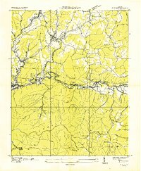
1935 Map of Wise
USGS Topo · Published 1935About this map
Wise and Norton anchor this 1935 industrial landscape during a period of intensive coal production and rail transport. The map documents a complex infrastructure of Tramways, the Interstate Railroad, and the Norfolk and Western Railway as they navigate the winding Guest River and the slopes of Powell Mountain. Notable coal operations like Cinchfield Coal No 15 and Wise No 11 are situated alongside smaller mining settlements like Glamorgan and Esserville.
Find a feature on this map
58 named features on this map. Tap any name to fly to it.
Don’t see what you’re looking for? This feature index may not catch every label — zoom into the map to look around manually.
Map Details
Editions of this 1935 Wise Map
This is the sole edition of this map. No revisions or reprints were ever made.
Other maps of this area

1886 · Grundy
USGS Topo · 1:125,000

1890 · Whitesburg
USGS Topo · 1:125,000

1890 · Grundy
USGS Topo · 1:125,000

1892 · Grundy
USGS Topo · 1:125,000

1892 · Whitesburg
USGS Topo · 1:125,000

1894 · Estillville
USGS Topo · 1:125,000

1897 · Bristol
USGS Topo · 1:125,000

1902 · Bristol
USGS Topo · 1:125,000

1912 · Pound
USGS Topo · 1:48,000

1913 · Clintwood
USGS Topo · 1:62,500