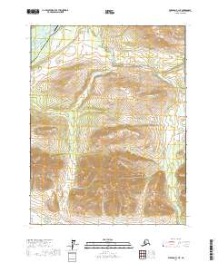
2017 Map of Wiseman A-1 NE
USGS Topo · Published 2017About this map
Coldfoot serves as a critical northern outpost along the Dalton Highway, situated where the Middle Fork Koyukuk River winds through the interior. The landscape is defined by the vital infrastructure of the Alaska Pipeline, which runs parallel to the highway, supporting the state's energy corridor. The terrain rises sharply from the river valley toward prominent heights such as Cathedral Mtn, while several passes like Rosie Creek Pass and Sitkum Pass provide natural transitions between drainage basins. Aviation access is centered at the Coldfoot Airport, reflecting the area's role as a logistical hub for the surrounding wilderness. The map details numerous waterways, including Slate Creek and Hungarian Cr, which carve through the high-elevation topography and feed into the larger Koyukuk system.
Find a feature on this map
16 named features on this map. Tap any name to fly to it.
Don’t see what you’re looking for? This feature index may not catch every label — zoom into the map to look around manually.
Map Details
Editions of this 2017 Wiseman A-1 NE Map
This is the sole edition of this map. No revisions or reprints were ever made.
Other maps of this area

1951 · Chandalar
USGS Topo · 1:250,000

1951 · Wiseman
USGS Topo · 1:250,000

1956 · Chandalar
USGS Topo · 1:250,000

1956 · Wiseman
USGS Topo · 1:250,000

1964 · Wiseman
USGS Topo · 1:250,000

1964 · Chandalar
USGS Topo · 1:250,000

1970 · Wiseman A-1
USGS Topo · 1:63,360
1970 · Chandalar A-6
USGS Topo · 1:63,360
1971 · Wiseman B-1
USGS Topo · 1:63,360
1971 · Chandalar B-6
USGS Topo · 1:63,360