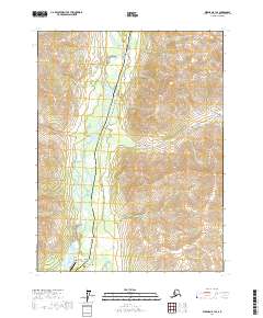
2017 Map of Wiseman B-1 SE
USGS Topo · Published 2017About this map
Coldfoot serves as a critical infrastructure hub along the Dalton Highway, marking a rare point of human settlement in the Brooks Range foothills. This 2017 survey details the complex corridor where the highway, the Alaska Pipeline, and the Middle Fork Koyukuk River run in parallel through the valley. The geography here is defined by these modern industrial lifelines, supported by the Coldfoot Airport and a small network of local paths like Airport Road. Numerous drainages flow from the surrounding elevations into the river system, including Marion Cr, Emma Cr, and Slate Cr. These watercourses, along with Dry Gulch and Kelly Gulch, highlight the drainage patterns that dominate the landscape between the surveyed township lines of t29n r12w and t28n r11w.
Find a feature on this map
17 named features on this map. Tap any name to fly to it.
Don’t see what you’re looking for? This feature index may not catch every label — zoom into the map to look around manually.
Map Details
Editions of this 2017 Wiseman B-1 SE Map
This is the sole edition of this map. No revisions or reprints were ever made.
Other maps of this area

1951 · Chandalar
USGS Topo · 1:250,000

1951 · Wiseman
USGS Topo · 1:250,000

1956 · Chandalar
USGS Topo · 1:250,000

1956 · Wiseman
USGS Topo · 1:250,000

1964 · Wiseman
USGS Topo · 1:250,000

1964 · Chandalar
USGS Topo · 1:250,000

1970 · Wiseman A-1
USGS Topo · 1:63,360
1970 · Chandalar A-6
USGS Topo · 1:63,360
1971 · Wiseman B-1
USGS Topo · 1:63,360
1971 · Chandalar B-6
USGS Topo · 1:63,360