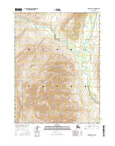
2016 Map of Wiseman C-3 SE
USGS Topo · Published 2016About this map
Gates Of The Arctic National Park encompasses the entire landscape of this 2016 survey, representing a portion of the Brooks Range where the North Fork Koyukuk River and its major tributaries define the drainage patterns. The Tinayguk River meanders through the central and western sections of the quadrangle, eventually meeting the North Fork in the east. This area is characterized by high-latitude hydrology and dramatic elevation shifts shown by 80-foot contours. Smaller waterways like Pass Cr and Clear River carve through the northern reaches, illustrating the complex watershed of the Koyukuk system. The map serves as a record of federally protected wilderness in the early 21st century, showing the intersection of surveyed township boundaries such as t32n r16w with the natural flow of Arctic rivers.
Find a feature on this map
9 named features on this map. Tap any name to fly to it.
Don’t see what you’re looking for? This feature index may not catch every label — zoom into the map to look around manually.
Map Details
Editions of this 2016 Wiseman C-3 SE Map
This is the sole edition of this map. No revisions or reprints were ever made.
Other maps of this area

1951 · Wiseman
USGS Topo · 1:250,000

1956 · Wiseman
USGS Topo · 1:250,000

1964 · Wiseman
USGS Topo · 1:250,000

1971 · Wiseman C-2
USGS Topo · 1:63,360
1971 · Wiseman B-3
USGS Topo · 1:63,360
1971 · Wiseman B-2
USGS Topo · 1:63,360
1971 · Wiseman C-3
USGS Topo · 1:63,360
2016 · Wiseman C-3 NE
USGS Topo · 1:25,000
2016 · Wiseman C-3 NW
USGS Topo · 1:25,000
2016 · Wiseman C-3 SW
USGS Topo · 1:25,000