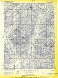
1971 Map of Wiseman B-3
USGS Topo · Published 1974About this map
Wild River meanders through this portion of the Yukon-Koyukuk region, its braided channels and sharp oxbows carving a complex path across the valley floor. The 1971 data illustrates a remote landscape where human presence is marked only by isolated Cabin and Cabins structures along the water and higher ground. High-elevation landmarks like Madison Mountain and Inner Mountain define the local topography, overlooking the drainage systems of Agnes Creek and Michigan Creek. A notable feature of the local transport network is the Winter Trail, which cuts through the terrain west of the river, indicating a reliance on seasonal routes for movement through this wilderness. The area around East Fork remains largely undeveloped, showcasing the raw geological character of the Brooks Range foothills before further modern intrusion.
Find a feature on this map
9 named features on this map. Tap any name to fly to it.
Don’t see what you’re looking for? This feature index may not catch every label — zoom into the map to look around manually.
Map Details
Editions of this 1971 Wiseman B-3 Map
2 editions found
Other maps of this area

1951 · Wiseman
USGS Topo · 1:250,000

1956 · Wiseman
USGS Topo · 1:250,000

1964 · Wiseman
USGS Topo · 1:250,000

1970 · Wiseman A-4
USGS Topo · 1:63,360

1970 · Wiseman A-3
USGS Topo · 1:63,360

1970 · Wiseman A-2
USGS Topo · 1:63,360

1971 · Wiseman C-2
USGS Topo · 1:63,360

1971 · Wiseman C-4
USGS Topo · 1:63,360
1971 · Wiseman B-2
USGS Topo · 1:63,360
1971 · Wiseman C-3
USGS Topo · 1:63,360