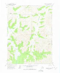
1971 Map of Wiseman B-3
USGS Topo · Published 1975About this map
Wild River winds through this interior Alaskan landscape, serving as the primary drainage for a network of creeks including Scofield Creek and Madison Cr. The terrain is defined by prominent elevations such as Ipnek Mountain and Mathews Dome, which overlook a complex system of waterways. A Winter Trail provides a historical glimpse into the seasonal movement patterns in this remote region, crossing through the expansive Flat. Small, unnamed Cabin and Cabins sites are noted along Birch Creek and near the headwaters of Rye Creek, suggesting localized trapping, mining, or hunting activity during the early 1970s. The drainage patterns of Michigan Creek and its East Fork Michigan Creek dominate the southeastern portion of the quadrangle, illustrating the intricate hydrology of the Yukon-Koyukuk region.
Find a feature on this map
15 named features on this map. Tap any name to fly to it.
Don’t see what you’re looking for? This feature index may not catch every label — zoom into the map to look around manually.
Map Details
Editions of this 1971 Wiseman B-3 Map
2 editions found
Other maps of this area

1951 · Wiseman
USGS Topo · 1:250,000

1956 · Wiseman
USGS Topo · 1:250,000

1964 · Wiseman
USGS Topo · 1:250,000

1970 · Wiseman A-4
USGS Topo · 1:63,360

1970 · Wiseman A-3
USGS Topo · 1:63,360

1970 · Wiseman A-2
USGS Topo · 1:63,360

1971 · Wiseman C-2
USGS Topo · 1:63,360

1971 · Wiseman C-4
USGS Topo · 1:63,360
1971 · Wiseman B-3
USGS Topo · 1:63,360
1971 · Wiseman B-2
USGS Topo · 1:63,360