
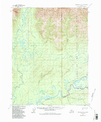
1970 Map of Wiseman A-3
USGS Topo · Published 1973About this map
The Koyukuk River dominates the southern landscape of this northern Alaska region, where the North Fork and Middle Fork converge amidst a complex network of meanders and oxbow lakes. To the north, the terrain rises toward Gilroy Mountain, with the Wild River and its tributary Gilroy Creek cutting through the western lowlands. An interesting geological detail is the presence of Pingos near the center of the sheet, indicating the permafrost-driven landforms characteristic of the Brooks Range foothills.
Find a feature on this map
14 named features on this map. Tap any name to fly to it.
Don’t see what you’re looking for? This feature index may not catch every label — zoom into the map to look around manually.
Map Details
Editions of this 1970 Wiseman A-3 Map
2 editions found
Other maps of this area

1951 · Bettles
USGS Topo · 1:250,000

1951 · Wiseman
USGS Topo · 1:250,000

1956 · Bettles
USGS Topo · 1:250,000

1956 · Wiseman
USGS Topo · 1:250,000

1964 · Wiseman
USGS Topo · 1:250,000

1970 · Bettles D-4
USGS Topo · 1:63,360

1970 · Wiseman A-4
USGS Topo · 1:63,360

1970 · Wiseman A-2
USGS Topo · 1:63,360

1970 · Bettles D-3
USGS Topo · 1:63,360

1970 · Bettles D-2
USGS Topo · 1:63,360