
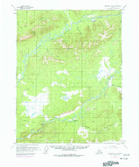
1970 Map of Bettles D-2
USGS Topo · Published 1973About this map
The South Fork Koyukuk River winds through this interior Alaskan wilderness, carving a path between the Jack White Range and the surrounding drainage basins. This 1970 aerial survey documents a landscape defined by its waterways and seasonal transit routes, showing the Winter Trail and Winter Road that provided access before permanent infrastructure was established. Evidence of local industry is found at the Gold Bench Placer Mine, located near the northern reaches of the river, while a Landing Strip and the Prospect Uncamp near Prospect Creek indicate the logistical footprints of resource exploration or maintenance. Tributaries like Jim River and Hudson Bay Creek feed the main fork, illustrating the intricate hydrology of the Yukon-Koyukuk region during a period of increasing northern development.
Find a feature on this map
16 named features on this map. Tap any name to fly to it.
Don’t see what you’re looking for? This feature index may not catch every label — zoom into the map to look around manually.
Map Details
Editions of this 1970 Bettles D-2 Map
2 editions found
Other maps of this area

1951 · Bettles
USGS Topo · 1:250,000

1951 · Wiseman
USGS Topo · 1:250,000

1956 · Bettles
USGS Topo · 1:250,000

1956 · Wiseman
USGS Topo · 1:250,000

1964 · Wiseman
USGS Topo · 1:250,000

1970 · Wiseman A-1
USGS Topo · 1:63,360
1970 · Bettles D-1
USGS Topo · 1:63,360

1970 · Wiseman A-3
USGS Topo · 1:63,360

1970 · Wiseman A-2
USGS Topo · 1:63,360
1970 · Bettles C-1
USGS Topo · 1:63,360