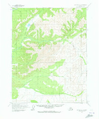
1970 Map of Bettles D-1
USGS Topo · Published 1973About this map
The S Fk Koyukuk R and Jim River define this interior Alaska landscape, captured during a period of expanding northern infrastructure. A prominent Winter Road cuts diagonally through the northern terrain, crossing Grayling Creek and passing just east of Grayling Lake. This seasonal route reflects the historical reliance on frozen ground for overland transport in the Brooks Range foothills before permanent highway development reached this far north. The drainage network is dense with tributaries such as Prospect Creek, Douglas Creek, and Bear Creek, which carve through high ridges and valleys. While no permanent settlements are labeled, the detailed mapping of these watercourses and the winter corridor indicates the region's importance for early resource exploration and seasonal transit routes between the Koyukuk and Chandalar basins.
Find a feature on this map
16 named features on this map. Tap any name to fly to it.
Don’t see what you’re looking for? This feature index may not catch every label — zoom into the map to look around manually.
Map Details
Editions of this 1970 Bettles D-1 Map
3 editions found
Other maps of this area

1951 · Bettles
USGS Topo · 1:250,000

1951 · Chandalar
USGS Topo · 1:250,000

1951 · Beaver
USGS Topo · 1:250,000

1951 · Wiseman
USGS Topo · 1:250,000

1956 · Chandalar
USGS Topo · 1:250,000

1956 · Bettles
USGS Topo · 1:250,000

1956 · Wiseman
USGS Topo · 1:250,000

1956 · Beaver
USGS Topo · 1:250,000

1964 · Wiseman
USGS Topo · 1:250,000

1964 · Chandalar
USGS Topo · 1:250,000