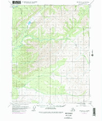
1970 Map of Bettles D-1
USGS Topo · Published 1977About this map
The Trans-Alaska Pipeline is the defining human feature of this interior Alaska landscape, shown here as it was under construction in the 1970s. The pipeline route cuts diagonally across the terrain, crossing the upper reaches of Jim River and skirting the edge of Grayling Lake. This period of development marked a significant change for the region, introducing industrial infrastructure into a wilderness defined by its extensive drainage systems. The map details the complex network of waterways that flow through the area, including S K Koyukuk R, Prospect Creek, and Douglas Creek. Smaller tributaries such as Bear Creek, Davis Creek, and Grayling Creek feed these larger systems, illustrating the hydrological patterns of the northern wilderness before the full completion of the energy corridor. The topographic data reflects the survey work of the U.S. Geological Survey and the Bureau of Land Management as they mapped unsurveyed land lines during this era of infrastructure expansion.
Find a feature on this map
14 named features on this map. Tap any name to fly to it.
Don’t see what you’re looking for? This feature index may not catch every label — zoom into the map to look around manually.
Map Details
Editions of this 1970 Bettles D-1 Map
3 editions found
Other maps of this area

1951 · Bettles
USGS Topo · 1:250,000

1951 · Chandalar
USGS Topo · 1:250,000

1951 · Beaver
USGS Topo · 1:250,000

1951 · Wiseman
USGS Topo · 1:250,000

1956 · Chandalar
USGS Topo · 1:250,000

1956 · Bettles
USGS Topo · 1:250,000

1956 · Wiseman
USGS Topo · 1:250,000

1956 · Beaver
USGS Topo · 1:250,000

1964 · Wiseman
USGS Topo · 1:250,000

1964 · Chandalar
USGS Topo · 1:250,000