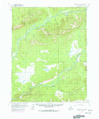
1970 Map of Bettles D-2
USGS Topo · Published 1977About this map
The Trans-Alaska Pipeline cuts through this northern landscape during its mid-1970s development, illustrating the intersection of industrial expansion and the Alaskan interior. This era shows a transition from traditional routes like the Winter Trail and Winter Road to major infrastructure projects. Along the South Fork Koyukuk River, evidence of the region’s mineral history is visible at the Gold Bench Placer Mine and Ironsides Bar Mine. The importance of aviation in this remote sector is highlighted by Prospect Airport and a separate Landing Strip near the John River. Central to the activity in the southern half of the sheet is the Prospect Creek Camp, which supported the construction crews and logistical operations near the Jim River. The map provides a detailed view of the terrain before the pipeline corridor became a permanent fixture of the geography.
Find a feature on this map
25 named features on this map. Tap any name to fly to it.
Don’t see what you’re looking for? This feature index may not catch every label — zoom into the map to look around manually.
Map Details
Editions of this 1970 Bettles D-2 Map
2 editions found

Other maps of this area

1951 · Bettles
USGS Topo · 1:250,000

1951 · Wiseman
USGS Topo · 1:250,000

1956 · Bettles
USGS Topo · 1:250,000

1956 · Wiseman
USGS Topo · 1:250,000

1964 · Wiseman
USGS Topo · 1:250,000

1970 · Wiseman A-1
USGS Topo · 1:63,360
1970 · Bettles D-1
USGS Topo · 1:63,360

1970 · Wiseman A-3
USGS Topo · 1:63,360

1970 · Wiseman A-2
USGS Topo · 1:63,360
1970 · Bettles C-1
USGS Topo · 1:63,360