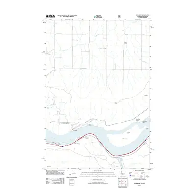
2011 Map of Wishram
USGS Topo · Published 2011About this map
The Columbia River serves as the focal point of this 2011 survey, marking the jurisdictional boundary between Washington and Oregon. On the northern bank, the settlement of Wishram and the adjacent Wishram Heights sit at a significant geographical bend, where the Oregon Trunk Junction highlights the importance of rail transit through the river corridor. To the south, Celilo Village and the Celilo Indian Cemetery reflect the long-standing indigenous presence and cultural history associated with this reach of the river.
Find a feature on this map
48 named features on this map. Tap any name to fly to it.
Don’t see what you’re looking for? This feature index may not catch every label — zoom into the map to look around manually.
Map Details
Editions of this 2011 Wishram Map
This is the sole edition of this map. No revisions or reprints were ever made.
Other maps of this area

1934 · The Dalles
USGS Topo · 1:125,000

1953 · The Dalles
USGS Topo · 1:250,000

1956 · The Dalles
USGS Topo · 1:250,000

1957 · The Dalles
USGS Topo · 1:250,000

1957 · Klickitat
USGS Topo · 1:62,500

1957 · Goldendale
USGS Topo · 1:62,500

1957 · The Dalles
USGS Topo · 1:62,500

1957 · Wishram
USGS Topo · 1:62,500

1974 · Stacker Butte
USGS Topo · 1:24,000
1974 · Locust Grove
USGS Topo · 1:24,000