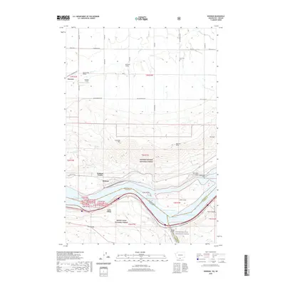
2020 Map of Wishram
USGS Topo · Published 2020About this map
Wishram and Wishram Heights overlook the northern bank of the Columbia River, situated at a dramatic point where the river cuts through the Columbia Hills. This region, documented in 2020, serves as a critical corridor between Washington and Oregon, featuring the expansive waters of Lake Celilo and the complex channels surrounding Miller Island. Further south, Celilo Village remains a significant settlement on the Oregon side, while the Mount Hood National Forest and Gifford Pinchot National Forest meet across the state boundary. To the north, the terrain transitions into the Klickitat Valley, where the Centerville Cem and the small community of Warwick are located. The map also traces the Klickitat State Park Trail, indicating the repurposing of transport routes through this land of high ridges like Fulton Ridge and prominent landmarks such as Haystack Butte.
Find a feature on this map
57 named features on this map. Tap any name to fly to it.
Don’t see what you’re looking for? This feature index may not catch every label — zoom into the map to look around manually.
Map Details
Editions of this 2020 Wishram Map
This is the sole edition of this map. No revisions or reprints were ever made.
Other maps of this area

1934 · The Dalles
USGS Topo · 1:125,000

1953 · The Dalles
USGS Topo · 1:250,000

1956 · The Dalles
USGS Topo · 1:250,000

1957 · The Dalles
USGS Topo · 1:250,000

1957 · Klickitat
USGS Topo · 1:62,500

1957 · Goldendale
USGS Topo · 1:62,500

1957 · The Dalles
USGS Topo · 1:62,500

1957 · Wishram
USGS Topo · 1:62,500

1974 · Stacker Butte
USGS Topo · 1:24,000
1974 · Locust Grove
USGS Topo · 1:24,000