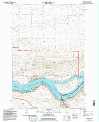
1994 Map of Wishram
USGS Topo · Published 1995About this map
Lake Celilo and the Columbia River dominate this mid-1990s survey, marking the deep geographic and political boundary between Washington and Oregon. The landscape transitions from the agricultural reaches of Centerville Valley in the north, past Dalles Mountain, and down the steep cliffs of the Columbia Hills into the Columbia River Gorge. This map captures a complex corridor of transport and conservation, where the Oregon-Trunk Jct and various gaging stations operate alongside the protected lands of the Gifford Pinchot National Forest and the Columbia River Gorge National Scenic Area. Settlement patterns are concentrated along the river at Wishram and Celilo Village, while the uplands maintain a rural character defined by old family-named routes like Uecker Road and Mattson Road, leading to the small community of Warwick and the Centerville Cem.
Find a feature on this map
40 named features on this map. Tap any name to fly to it.
Don’t see what you’re looking for? This feature index may not catch every label — zoom into the map to look around manually.
Map Details
Editions of this 1994 Wishram Map
This is the sole edition of this map. No revisions or reprints were ever made.
Other maps of this area

1934 · The Dalles
USGS Topo · 1:125,000

1953 · The Dalles
USGS Topo · 1:250,000

1956 · The Dalles
USGS Topo · 1:250,000

1957 · The Dalles
USGS Topo · 1:250,000

1957 · Klickitat
USGS Topo · 1:62,500

1957 · Goldendale
USGS Topo · 1:62,500

1957 · The Dalles
USGS Topo · 1:62,500

1957 · Wishram
USGS Topo · 1:62,500

1974 · Stacker Butte
USGS Topo · 1:24,000
1974 · Locust Grove
USGS Topo · 1:24,000