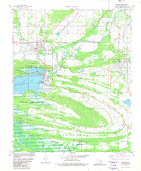
1981 Map of Wister
USGS Topo · Published 1981About this map
Wister and Howe anchor this 1981 landscape, where the Poteau River system was significantly altered by the impoundment of Wister Lake. The map reveals a complex water management infrastructure, including sewage disposal ponds, a massive spillway, and multiple gaging stations that monitor the river's flow through the Wister Lake State Park. Transportation corridors are dominated by the Burlington Northern and Kansas City Southern railroads, which traverse the terrain alongside established settlements like Yerby and Independence.
Find a feature on this map
66 named features on this map. Tap any name to fly to it.
Don’t see what you’re looking for? This feature index may not catch every label — zoom into the map to look around manually.
Map Details
Editions of this 1981 Wister Map
This is the sole edition of this map. No revisions or reprints were ever made.
Other maps of this area

1900 · Sallisaw
USGS Topo · 1:125,000

1900 · Winding Stair
USGS Topo · 1:125,000

1909 · Winding Stair
USGS Topo · 1:125,000

1911 · Sallisaw
USGS Topo · 1:125,000

1946 · Fort Smith
USGS Topo · 1:250,000

1950 · Mcalester
USGS Topo · 1:250,000

1959 · Heavener
USGS Topo · 1:62,500

1962 · McAlester
USGS Topo · 1:250,000

1965 · Fort Smith
USGS Topo · 1:250,000

1965 · McAlester
USGS Topo · 1:250,000