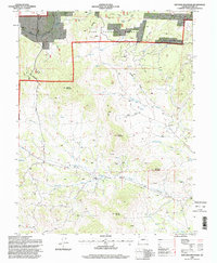
1994 Map of Witcher Mountain
USGS Topo · Published 1998About this map
Witcher Mountain and the high volcanic peaks of central Colorado define this area of the Pike National Forest in the mid-1990s. The landscape is marked by modern infrastructure integrated into the high-country terrain, notably the Homestake Pipeline and an Aqueduct running through the northern gulches. Significant relief is provided by prominent summits like Saddle Mountain and Castle Mountain, while lower elevations are carved by Fourmile Creek and Cottonwood Creek.
Find a feature on this map
25 named features on this map. Tap any name to fly to it.
Don’t see what you’re looking for? This feature index may not catch every label — zoom into the map to look around manually.
Map Details
Editions of this 1994 Witcher Mountain Map
This is the sole edition of this map. No revisions or reprints were ever made.
Other maps of this area

1894 · Pikes Peak
USGS Topo · 1:125,000

1901 · Pikes Peak
USGS Topo · 1:125,000

1942 · Cover Mtn.
USGS Topo · 1:62,500

1948 · Cover Mtn.
USGS Topo · 1:62,500

1954 · Pueblo
USGS Topo · 1:250,000

1956 · Lake George
USGS Topo · 1:24,000

1956 · Elevenmile Canyon
USGS Topo · 1:24,000

1956 · Spinney Mountain
USGS Topo · 1:24,000

1957 · Pueblo
USGS Topo · 1:250,000

1958 · Pueblo
USGS Topo · 1:250,000