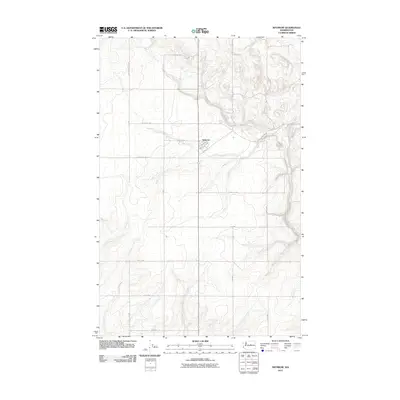
2011 Map of Withrow
USGS Topo · Published 2011About this map
Withrow serves as the central hub for this high plateau region in Douglas County, situated at the intersection of a vast grid of section roads. The small settlement, defined by streets such as 1st Ave and 2nd Ave, is surrounded by a landscape organized for agricultural production. A systematic network of rural routes, including Christenson Rd Nw, Slusser Rd Nw, and Oakland Rd Nw, facilitates movement across the undulating terrain. This 2011 survey captures the area's enduring reliance on traditional land divisions, where numbered roads like Road 8 Nw and Road 5 Nw cross the open country. The intricate contour lines reveal the deep coulees and draws that break the otherwise steady geometry of the northern Washington plains.
Find a feature on this map
22 named features on this map. Tap any name to fly to it.
Don’t see what you’re looking for? This feature index may not catch every label — zoom into the map to look around manually.
Map Details
Editions of this 2011 Withrow Map
This is the sole edition of this map. No revisions or reprints were ever made.
Other maps of this area

1953 · Ritzville
USGS Topo · 1:250,000

1959 · Ritzville
USGS Topo · 1:250,000

1965 · Ritzville
USGS Topo · 1:250,000

1965 · Jameson Lake SW
USGS Topo · 1:24,000

1965 · Jameson Lake West
USGS Topo · 1:24,000

1968 · Withrow
USGS Topo · 1:24,000

1968 · Lamoine
USGS Topo · 1:24,000

1968 · Chelan Falls
USGS Topo · 1:24,000
1968 · Alstown
USGS Topo · 1:24,000
1968 · Mud Spring
USGS Topo · 1:24,000