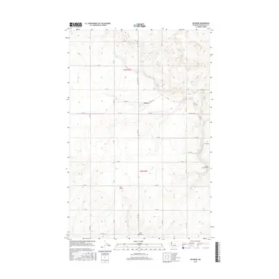
2017 Map of Withrow
USGS Topo · Published 2017About this map
The settlement of Withrow anchors this portion of Douglas County, situated in a high agricultural plateau marked by the geometric precision of the Public Land Survey System. The landscape is defined by the sharp transition from level fields to the dramatic depression of Pine Canyon in the southwest and Dutch Henry Draw to the east. Historically significant for genealogists, the Farmer Happy Home Cem sits near the southern edge of the map, serving as a landmark for the community of Farmer. The grid of county roads, including Berg Rd and Withrow Rd NW, illustrates the enduring structure of the region's wheat-growing economy and rural transport network, where high-elevation plateaus meet the deep Coulee-style drainage systems characteristic of central Washington.
Find a feature on this map
28 named features on this map. Tap any name to fly to it.
Don’t see what you’re looking for? This feature index may not catch every label — zoom into the map to look around manually.
Map Details
Editions of this 2017 Withrow Map
This is the sole edition of this map. No revisions or reprints were ever made.
Other maps of this area

1953 · Ritzville
USGS Topo · 1:250,000

1959 · Ritzville
USGS Topo · 1:250,000

1965 · Ritzville
USGS Topo · 1:250,000

1965 · Jameson Lake SW
USGS Topo · 1:24,000

1965 · Jameson Lake West
USGS Topo · 1:24,000

1968 · Withrow
USGS Topo · 1:24,000

1968 · Lamoine
USGS Topo · 1:24,000

1968 · Chelan Falls
USGS Topo · 1:24,000
1968 · Alstown
USGS Topo · 1:24,000
1968 · Mud Spring
USGS Topo · 1:24,000