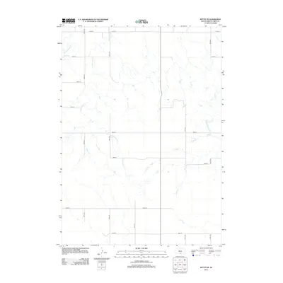
2012 Map of Witten SE
USGS Topo · Published 2012About this map
W Cottonwood Cr and E Cottonwood Cr wind through this rural section of South Dakota, defining a landscape shaped by drainage patterns of the northern plains. This topographic survey from the early 2010s reveals a strictly gridded agricultural framework, where long-distance gravel and dirt roads like 278th St and 303rd Ave provide the primary infrastructure for ranching and farming operations. The terrain is marked by intermittent watercourses, including the meandering path of Hollow Cr in the eastern half of the map. This area represents the open, sparsely populated character of the region, where the intersection of section lines and natural drainage features dictates the placement of homesteads and grazing lands.
Find a feature on this map
16 named features on this map. Tap any name to fly to it.
Don’t see what you’re looking for? This feature index may not catch every label — zoom into the map to look around manually.
Map Details
Editions of this 2012 Witten SE Map
This is the sole edition of this map. No revisions or reprints were ever made.
Other maps of this area

1955 · Martin
USGS Topo · 1:250,000

1955 · Mitchell
USGS Topo · 1:250,000

1958 · Martin
USGS Topo · 1:250,000

1959 · Mitchell
USGS Topo · 1:250,000

1982 · Witten SE
USGS Topo · 1:25,000

1982 · Witten
USGS Topo · 1:25,000
1982 · Miller Hill
USGS Topo · 1:25,000

1982 · Witten SW
USGS Topo · 1:25,000
1982 · Clearfield
USGS Topo · 1:24,000
1982 · Keyapaha NW
USGS Topo · 1:24,000