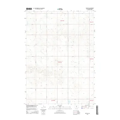
2015 Map of Witten SE
USGS Topo · Published 2015About this map
Little Dog Ear Lake anchors the southern reaches of this landscape in Tripp County, where the plains are defined by a network of seasonal watercourses and a strict section-line road grid. The drainage patterns of E Cottonwood Cr and W Cottonwood Cr reveal the subtle topographic shifts of the South Dakota prairie, creating a branching system of draws that break up the agricultural blocks. Further east, the terrain is shaped by the winding paths of Hollow Cr and the area simply labeled Hollow. This 2015 survey illustrates the enduring nature of the Public Land Survey System, with roads like 282nd St and 304th Ave following precise township and range boundaries established over a century ago.
Find a feature on this map
24 named features on this map. Tap any name to fly to it.
Don’t see what you’re looking for? This feature index may not catch every label — zoom into the map to look around manually.
Map Details
Editions of this 2015 Witten SE Map
This is the sole edition of this map. No revisions or reprints were ever made.
Other maps of this area

1955 · Martin
USGS Topo · 1:250,000

1955 · Mitchell
USGS Topo · 1:250,000

1958 · Martin
USGS Topo · 1:250,000

1959 · Mitchell
USGS Topo · 1:250,000

1982 · Witten SE
USGS Topo · 1:25,000

1982 · Witten
USGS Topo · 1:25,000
1982 · Miller Hill
USGS Topo · 1:25,000

1982 · Witten SW
USGS Topo · 1:25,000
1982 · Clearfield
USGS Topo · 1:24,000
1982 · Keyapaha NW
USGS Topo · 1:24,000