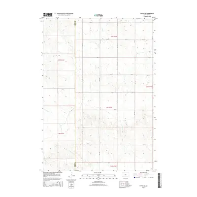
2015 Map of Witten SW
USGS Topo · Published 2015About this map
De Bell Cr and W Cottonwood Cr flow through a landscape defined by the section-line grid of the Great Plains, located along the boundary of Todd Co and Tripp Co. This territory in south-central South Dakota is etched with intermittent drainages such as E White Horse Cr and Willow Cr, which snake through the varied elevation of the Rosebud region. The map reveals a strictly organized rural infrastructure, where gravel roads like 278th St and 300th Ave trace the legal boundaries of the Public Land Survey System. The transition from the t39n r25w townships in the west to t99n r79w in the east highlights the convergence of different surveying blocks across the county line, providing a clear record of land division and water access in this ranching country.
Find a feature on this map
25 named features on this map. Tap any name to fly to it.
Don’t see what you’re looking for? This feature index may not catch every label — zoom into the map to look around manually.
Map Details
Editions of this 2015 Witten SW Map
This is the sole edition of this map. No revisions or reprints were ever made.
Other maps of this area

1955 · Martin
USGS Topo · 1:250,000

1958 · Martin
USGS Topo · 1:250,000

1982 · Witten SE
USGS Topo · 1:25,000

1982 · Witten
USGS Topo · 1:25,000

1982 · Witten SW
USGS Topo · 1:25,000
1982 · Clearfield
USGS Topo · 1:24,000

1982 · Okreek SE
USGS Topo · 1:24,000
1982 · Keyapaha NW
USGS Topo · 1:24,000
1982 · Carter
USGS Topo · 1:25,000

1982 · Mosher
USGS Topo · 1:25,000