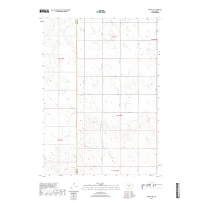
2017 Map of Witten SW
USGS Topo · Published 2017About this map
Todd County and Tripp County divide this prairie landscape, where a network of section-line roads follows the rectilinear township and range grid common across the Great Plains. The terrain is defined by the headwaters of several drainage systems, including De Bell Cr and W Cottonwood Cr in the north, while E White Horse Cr and Willow Cr carve through the southern portions of the quadrangle. This 2017 survey shows a primarily rural, agricultural region characterized by open range and subtle elevation changes, with the county line serving as a major administrative boundary. The absence of concentrated town sites emphasizes the area's pastoral nature, where human activity is reflected in the systematic numbering of avenues like 297th Ave and 299th Ave.
Find a feature on this map
24 named features on this map. Tap any name to fly to it.
Don’t see what you’re looking for? This feature index may not catch every label — zoom into the map to look around manually.
Map Details
Editions of this 2017 Witten SW Map
This is the sole edition of this map. No revisions or reprints were ever made.
Other maps of this area

1955 · Martin
USGS Topo · 1:250,000

1958 · Martin
USGS Topo · 1:250,000

1982 · Witten SE
USGS Topo · 1:25,000

1982 · Witten
USGS Topo · 1:25,000

1982 · Witten SW
USGS Topo · 1:25,000
1982 · Clearfield
USGS Topo · 1:24,000

1982 · Okreek SE
USGS Topo · 1:24,000
1982 · Keyapaha NW
USGS Topo · 1:24,000
1982 · Carter
USGS Topo · 1:25,000

1982 · Mosher
USGS Topo · 1:25,000