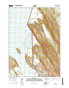
2017 Map of Wocus
USGS Topo · Published 2017About this map
Upper Klamath Lake and its intricate eastern shoreline dominate this landscape, where the foothills of the Cascade Range meet the water. The northern reaches of Klamath Falls are visible here, featuring the Oregon Institute of Technology campus and the settlement of Pelican City. The terrain transitions from the low-lying Hanks Marsh and Wocus Marsh to prominent elevations like Naylox Mtn and the Plum Hills. Historically significant infrastructure is noted through features like the Algoma Incline near the settlement of Algoma, reflecting the area's timber and transport heritage. Further inland, the map details numerous canyons such as Herlihy Canyon and Simpson Canyon, alongside smaller communities like Shady Pine and Wocus, providing a look at the residential and academic expansion north of the city center.
Find a feature on this map
70 named features on this map. Tap any name to fly to it.
Don’t see what you’re looking for? This feature index may not catch every label — zoom into the map to look around manually.
Map Details
Editions of this 2017 Wocus Map
This is the sole edition of this map. No revisions or reprints were ever made.
Other maps of this area

1889 · Klamath
USGS Topo · 1:250,000

1894 · Klamath
USGS Topo · 1:250,000

1955 · Klamath Falls
USGS Topo · 1:250,000

1957 · Merrill
USGS Topo · 1:62,500

1957 · Swan Lake
USGS Topo · 1:62,500

1957 · Klamath Falls
USGS Topo · 1:62,500

1957 · Modoc Point
USGS Topo · 1:62,500

1958 · Klamath Falls
USGS Topo · 1:250,000
1975 · Klamath Falls NE
USGS Topo · 1:24,000

1975 · Merrill NW
USGS Topo · 1:24,000