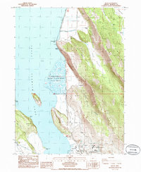
1985 Map of Wocus
USGS Topo · Published 1988About this map
The eastern shore of Upper Klamath Lake defines this mid-1980s landscape, where the Southern Pacific railroad tracks and Highway 97 trace the narrow corridor between the water and the rising terrain of Naylox Mountain and the Plum Hills. The transition from industrial and transport history to conservation is evident in the presence of the Upper Klamath National Wildlife Refuge and the ecologically significant Hanks Marsh.
Find a feature on this map
43 named features on this map. Tap any name to fly to it.
Don’t see what you’re looking for? This feature index may not catch every label — zoom into the map to look around manually.
Map Details
Editions of this 1985 Wocus Map
This is the sole edition of this map. No revisions or reprints were ever made.
Other maps of this area

1889 · Klamath
USGS Topo · 1:250,000

1894 · Klamath
USGS Topo · 1:250,000

1955 · Klamath Falls
USGS Topo · 1:250,000

1957 · Merrill
USGS Topo · 1:62,500

1957 · Swan Lake
USGS Topo · 1:62,500

1957 · Klamath Falls
USGS Topo · 1:62,500

1957 · Modoc Point
USGS Topo · 1:62,500

1958 · Klamath Falls
USGS Topo · 1:250,000
1975 · Klamath Falls NE
USGS Topo · 1:24,000

1975 · Merrill NW
USGS Topo · 1:24,000