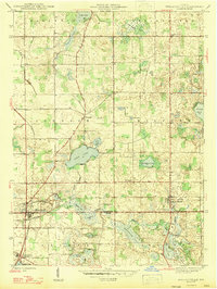
1947 Map of Wolcottville
USGS Topo · Published 1947About this map
The LaGrange Co Noble Co boundary line bisects a landscape of complex glacial hydrology, where deep-water basins and marshy flats define the local economy and settlement patterns. The industrial and transit hub of Wolcottville sits at the junction of two major rail systems: the Wabash and the Pennsylvania railroads. This rail infrastructure supported the surrounding agricultural community and unique institutions like the Kneipp Springs Sanitarium at the southern edge of the survey. The terrain is characterized by a dense concentration of water bodies, including the large Adam Lake and the elongated Tamarack Lake, which drain into the Elkhart River system. Local heritage is grounded in rural landmarks such as Brushy Chapel and the small settlements of Woodruff and South Milford, each anchored by generational sites like South Milford Cem and Bethel Cem.
Find a feature on this map
37 named features on this map. Tap any name to fly to it.
Don’t see what you’re looking for? This feature index may not catch every label — zoom into the map to look around manually.
Map Details
Editions of this 1947 Wolcottville Map
2 editions found
Other maps of this area

1940 · Orland
USGS Topo · 1:24,000

1941 · Orland
USGS Topo · 1:24,000

1942 · Stroh
USGS Topo · 1:24,000

1947 · Mongo
USGS Topo · 1:24,000

1947 · Lagrange
USGS Topo · 1:24,000

1947 · Wolcottville
USGS Topo · 1:24,000

1947 · Oliver Lake
USGS Topo · 1:24,000

1953 · Fort Wayne
USGS Topo · 1:250,000

1955 · Corunna
USGS Topo · 1:24,000

1955 · Kendallville
USGS Topo · 1:24,000