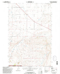
1995 Map of Wolf Butte NW
USGS Topo · Published 1997About this map
Wolf Butte rises above a landscape defined by seasonal coulees and headwater drainages in this mid-1990s revision of the Judith Basin Co terrain. The northern portion of the map is dominated by the Burlington Northern railroad corridor, while the southern reaches descend into the protected boundaries of the Lewis and Clark National Forest. The map traces a complex network of hydrological features, including the North Fork Surprise Creek, Lone Tree Creek, and the uniquely named Dipping Spring. This specific survey shows the region as it transitioned into the late 20th century, retaining its rural character with evidence of local resource extraction at a Gravel Pit and scattered Prospects. The 4th Standard Parallel North cuts across the center, serving as a primary surveying baseline for land navigation and property boundaries in this Montana rangeland.
Find a feature on this map
26 named features on this map. Tap any name to fly to it.
Don’t see what you’re looking for? This feature index may not catch every label — zoom into the map to look around manually.
Map Details
Editions of this 1995 Wolf Butte NW Map
This is the sole edition of this map. No revisions or reprints were ever made.
Other maps of this area

1890 · Fort Benton
USGS Topo · 1:250,000

1892 · Fort Benton
USGS Topo · 1:250,000

1897 · Fort Benton
USGS Topo · 1:250,000

1954 · Great Falls
USGS Topo · 1:250,000

1957 · Great Falls
USGS Topo · 1:250,000
1961 · Mixes Baldy
USGS Topo · 1:24,000
1961 · The Arch
USGS Topo · 1:24,000

1961 · Barker
USGS Topo · 1:62,500

1978 · Leiberg Coulee
USGS Topo · 1:24,000
1978 · Byrne Creek
USGS Topo · 1:24,000