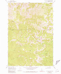
1969 Map of Wolf Fang Peak
USGS Topo · Published 1981About this map
Mining operations and high-altitude pack trails define this wilderness area along the border of Idaho and Valley Counties during the late 1960s. The landscape of the Payette National Forest is deeply etched by the various forks of Elk Creek and Wolf Fang Creek, where remote prospecting sites like the McCree Mine and Independence Mine suggest a history of resource extraction in difficult terrain. Evidence of earlier habitation or seasonal camps appears at Smokehouse (Ruins), located near the confluence of several unnamed drainages.
Find a feature on this map
33 named features on this map. Tap any name to fly to it.
Don’t see what you’re looking for? This feature index may not catch every label — zoom into the map to look around manually.
Map Details
Editions of this 1969 Wolf Fang Peak Map
2 editions found
Other maps of this area

1937 · Big Creek
USGS Topo · 1:48,000

1942 · Big Creek
USGS Topo · 1:62,500

1956 · Warren
USGS Topo · 1:62,500

1956 · Elk City
USGS Topo · 1:250,000

1960 · Elk City
USGS Topo · 1:250,000

1969 · Edwardsburg
USGS Topo · 1:24,000

1969 · Profile Gap
USGS Topo · 1:24,000

1969 · Parks Peak
USGS Topo · 1:24,000

1969 · Wolf Fang Peak
USGS Topo · 1:24,000

1969 · Big Creek
USGS Topo · 1:24,000