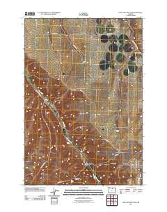
2011 Map of Wolf Hollow Falls
USGS Topo · Published 2011About this map
Rock Creek carves a central path through this section of the Oregon high plateau, defining a landscape marked by deep drainages and isolated agricultural holdings. The map illustrates a resilient ranching economy where named properties like Hartford Ranch, Baird Ranch, and Weatherford Ranch serve as primary landmarks in an otherwise open terrain. Connectivity is provided by a grid of rural routes, including Base Line RD and Ridge RD, which navigate the elevation changes between Wolf Hollow and Jordan Canyon. Significant to local history and genealogy, the Flett Cemetery sits near the junction of Upper Rock Creek RD and Flett RD, preserving the names of early inhabitants. The presence of Wolf Hollow Falls and Waterfalls Hollow near the southern boundary highlights the ephemeral water sources that have shaped the land use and movement of people through this corner of Gilliam County.
Find a feature on this map
22 named features on this map. Tap any name to fly to it.
Don’t see what you’re looking for? This feature index may not catch every label — zoom into the map to look around manually.
Map Details
Editions of this 2011 Wolf Hollow Falls Map
This is the sole edition of this map. No revisions or reprints were ever made.
Other maps of this area

1906 · Blalock Island
USGS Topo · 1:125,000

1908 · Blalock Island
USGS Topo · 1:125,000

1916 · Arlington
USGS Topo · 1:125,000

1916 · Condon
USGS Topo · 1:125,000

1953 · Pendleton
USGS Topo · 1:250,000

1953 · The Dalles
USGS Topo · 1:250,000

1956 · The Dalles
USGS Topo · 1:250,000

1956 · Pendleton
USGS Topo · 1:250,000

1957 · The Dalles
USGS Topo · 1:250,000

1964 · Shutler Flat
USGS Topo · 1:24,000