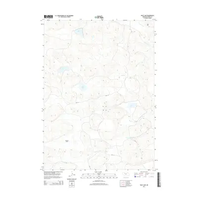
2014 Map of Wolf Lake
USGS Topo · Published 2014About this map
The North Loup River meanders through the southern reaches of this Sandhills landscape, creating a distinct riparian corridor amidst a region defined by isolated wetlands and subtle elevation shifts. This 2014 survey captures a sparsely populated section of Cherry County, where the hydrology is dominated by numerous small bodies of water including Wolf Lake, Rat Lake, and Evy Lake. These natural features, along with Pullman Valley and the prominent Aljo Hill, suggest a terrain primarily utilized for ranching and conservation. The infrastructure is minimal, consisting of rural routes like Carver Rd and Coble Rd which provide access to remote areas and the Coble Reservoir. The drainage patterns of Gordon Creek and Betsy Creek further illustrate the intricate water network that sustains this unique Nebraska environment.
Find a feature on this map
14 named features on this map. Tap any name to fly to it.
Don’t see what you’re looking for? This feature index may not catch every label — zoom into the map to look around manually.
Map Details
Editions of this 2014 Wolf Lake Map
This is the sole edition of this map. No revisions or reprints were ever made.
Other maps of this area

1949 · Steverson Lake
USGS Topo · 1:62,500

1950 · Doughboy
USGS Topo · 1:62,500

1950 · Wolf Lake
USGS Topo · 1:62,500

1951 · Steverson Lake
USGS Topo · 1:62,500

1951 · Wolf Lake
USGS Topo · 1:62,500

1951 · Merriman 4
USGS Topo · 1:62,500

1952 · Doughboy
USGS Topo · 1:62,500

1957 · Valentine
USGS Topo · 1:250,000

1959 · Valentine
USGS Topo · 1:250,000
1985 · Farm Flat
USGS Topo · 1:24,000