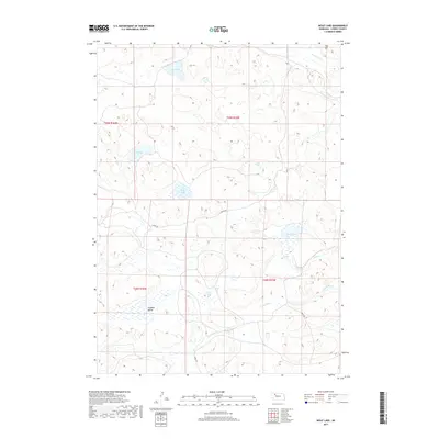
2017 Map of Wolf Lake
USGS Topo · Published 2017About this map
Wolf Lake and a dense network of Sandhills wetlands characterize this portion of Cherry County, where the hydrology of the High Plains Aquifer reaches the surface in numerous basins. The drainage pattern is defined by the headwaters of the N Loup River and Gordon Creek, which meander through a landscape of stabilized dunes and depressions like Pullman Valley. Human modification of this cattle-ranching country is represented by the Coble Reservoir and a sparse grid of section-line roads, including Carver Rd and Coble Rd. The map documents a complex system of shallow lakes, including Ivy Lake, Rat Lake, and the West Twin Lake, which are vital to the region's ecological and agricultural character. Notable elevations such as Aljo Hill provide some of the few distinct landmarks in this undulating terrain.
Find a feature on this map
19 named features on this map. Tap any name to fly to it.
Don’t see what you’re looking for? This feature index may not catch every label — zoom into the map to look around manually.
Map Details
Editions of this 2017 Wolf Lake Map
This is the sole edition of this map. No revisions or reprints were ever made.
Other maps of this area

1949 · Steverson Lake
USGS Topo · 1:62,500

1950 · Doughboy
USGS Topo · 1:62,500

1950 · Wolf Lake
USGS Topo · 1:62,500

1951 · Steverson Lake
USGS Topo · 1:62,500

1951 · Wolf Lake
USGS Topo · 1:62,500

1951 · Merriman 4
USGS Topo · 1:62,500

1952 · Doughboy
USGS Topo · 1:62,500

1957 · Valentine
USGS Topo · 1:250,000

1959 · Valentine
USGS Topo · 1:250,000
1985 · Farm Flat
USGS Topo · 1:24,000