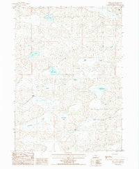
1987 Map of Wolf Lake
USGS Topo · Published 1987About this map
Pullman Valley and the surrounding Sandhills of Cherry County are defined by a complex network of seasonal lakes and winding watercourses as they appeared in the late 1980s. The landscape is dotted with isolated cattle operations such as Phillips Ranch, Becker Ranch, and Coble Ranch, reflecting the enduring ranching economy of this Nebraska region. Water is the primary geographic feature, with the North Loup River flowing through the southern portion while Gordon Creek cuts across the northern reaches. Numerous small bodies of water, including Wolf Lake, Rat Lake, and Duck Lake, suggest the high water table and interdunal basins characteristic of the area. This map provides a detailed view of the terrain elevations and the sparse network of unimproved roads that connected these remote homesteads and ranch lands.
Find a feature on this map
17 named features on this map. Tap any name to fly to it.
Don’t see what you’re looking for? This feature index may not catch every label — zoom into the map to look around manually.
Map Details
Editions of this 1987 Wolf Lake Map
This is the sole edition of this map. No revisions or reprints were ever made.
Other maps of this area

1949 · Steverson Lake
USGS Topo · 1:62,500

1950 · Doughboy
USGS Topo · 1:62,500

1950 · Wolf Lake
USGS Topo · 1:62,500

1951 · Steverson Lake
USGS Topo · 1:62,500

1951 · Wolf Lake
USGS Topo · 1:62,500

1951 · Merriman 4
USGS Topo · 1:62,500

1952 · Doughboy
USGS Topo · 1:62,500

1957 · Valentine
USGS Topo · 1:250,000

1959 · Valentine
USGS Topo · 1:250,000
1985 · Farm Flat
USGS Topo · 1:24,000